Pulau
Hantu
Habitats:
Four sandy lagoons, Northern lagoon with seagrass (Enhalus acoroides),
sparse corals. Outside the seawalls mainly rubble fringed with sparse
corals, denser reef cover on North west fringe. Tiny mangrove patch
between Hantu Besar and Hantu Kecil.
|
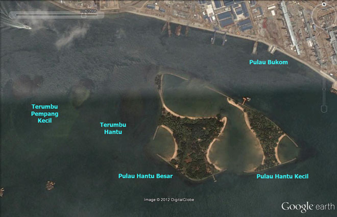
Pulau
Hantu
1° 13.539'N 103° 44.977'E
40ha, 900m x 400m
(from Google
Earth and Earth
Point)
Facilities: two jetties - one on Hantu Besar (facing South)
and another on Hantu Kecil (facing North). At low tide
it is possible to walk between Hantu Besar and Hantu Kecil.
A public toilet with freshwater (on Hantu Besar), many
shelters and picnic benches. |
|
|
Terumbu
Hantu
Habitats: Mostly rubble, sparse
reefy edges. More
in this post on the wild shores of singapore blog.
|
|
 |
Conservation
status: Pulau Hantu is listed for use as 'Beach Area' in
the URA
Master Plan 2008, i.e., "An area used or intended to be used
for coastal recreational purposes for the enjoyment of the general
public." Status not indicated in Parks
and Waterbodies Plan. It is managed by Sentosa
Leisure Group. Terumbu Hantu does not appear on the URA
Master Plan 2008 or the Parks
and Waterbodies Plan.
Mentioned in
the Singapore
Green Plan 2012 under "Marine Nature Areas":
"Singapores
surrounding waters bustle with large ships and small all hours
of the day, but thanks to effective pollution control, they also
teem with a rich variety of marine life.
Among our marine treasures are the pockets of coral reefs which
flourish to the south of Singapore, in particular around the St
Johns Island Group, Pulau Hantu, Pulau Semakau and the Pulau
Sudong Island Group. At these marine nature areas, numerous biological
communities - corals, sea-grasses, fishes, mangroves, marine mammals,
plankton and others - live in an abundance of aquatic harmony.
They are a never-ending source of wonderment to divers from Singapore
and elsewhere.
The government will keep these areas in their natural state for
as long as possible."
Current
conservation activities: Volunteers with the Hantu
Bloggers conduct monthly guided dives at Pulau Hantu to raise
awareness of marine life in Singapore. They also conduct public
talks at schools and other events. Various scientific projects are
also occasionally conducted on Pulau Hantu. Pulau Hantu is one of
the survey sites of underwater
coral reef surveys by ReefFriends
of NParks
and the Blue Water
Volunteers. The intertidal area is also regularly surveyed by
wildsingapore.
History: The current Pulau Hantu
is the result of massive reclamation. Hantu Besar used to be 2ha
and Hantu Kechil 0.4ha, surrounded by fringing reefs with a common
reef flat in between. Land reclamation from 1974-75 increased land
area to 12.2ha using 400,000m3 of sand, leaving a narrow strip between
rock bund and edge of the reef (about 20-30m). The original island
that stuck out above water at high tide is marked by untidy plant
growth, near the toilets.
|
| About
the names: Pulau=Island; Hantu=Ghost;
Terumbu=A reef or rock at low tide but submerged
at high water. |
|
|
| Blog
posts about Pulau Hantu on wild shores of singapore and
the Hantu Blog |
|
|
|
|