Lazarus
Island
Habitats:
Natural
rocky shore with pebbly stretches on southern edge. On eastern tip,
sandy centre with rubbly edges, sparse reef and sparse seagrasses.
On northern edge, narrow rocky area. Lush coastal forest in the centre.
|
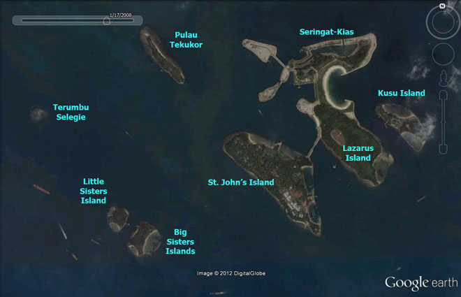
Lazarus Island
1° 13.301'N 103° 51.331'E
41ha, 1km x 400m
(from Google
Earth and Earth
Point)
Facilities: Lazarus and Seringat-Kias are connected by
paved trails. Connected to St. John's Island by a causeway.
Pontoon jetty at Seringat-Kias, step jetty at Lazarus. |
|
|
Seringat-Kias
Habitats:
Sandy beach with sparse seagrasses (Halophila ovalis, Halodule
sp.), sparsely reefy on artificial seawalls. |
|
 |
Conservation
status of Lazarus Island: Lazarus Island is listed for
use as 'Sports and Recreation' in the URA
Master Plan 2008, i.e., "Area to be used or intended to be
used mainly for sports and recreational purposes" and listed
as 'Park/Open Space' in Parks
and Waterbodies Plan.
Conservation status of Seringat-Kias:
Portions of Seringat-Kias are listed as 'Hotel' in the URA
Master Plan 2008, i.e., "Area to be used or intended to be
used mainly for hotel development. " Other portions are listed
as 'Residential', i.e., " Area to be used or intended to be used
mainly for residential development." Seringat-Kias is not listed
in Parks
and Waterbodies Plan.
Current conservation activities: The
intertidal area of Seringat-Kias and Lazarus Island are also regularly
surveyed by wildsingapore.
History: In 1974, reclamation at
Lazarus Island added 4ha. Lazarus Island was also affected by plans
in 2000 "to offer visitors a Mediterranean resort-like setting
only 17 minutes away by ferry, patterned after Italy's renowned vacation
spot, Capri". These plans include burying two submerged reefs,
Seringat or Renggit, and Kias, to form the artificial island now called
Seringat-Kias and joined to Lazarus Island, and the two joined to
St. John's Island with a causeway. There are also seawalls on the
eastern tip of Lazarus Island. More details on developments
impacting Lazarus Island and Seringat-Kias.
|
|
About
the name: Lazarus Island was originally
called Pulau Sakijang Pelepah: Sa=One; Kijang=barking
deer; Pelepah=palm frond.. It is not known why
it was renamed to Lazarus Island. The origins of the names
Seringat and Kias are not known. |
|
|
| Blog
posts about Lazarus Island and Seringat-Kias on wild shores
of singapore |
|
|
|
|