| |
|
this
page is a private link:
not to be disseminated
without prior permission from Ria hello@wildsingapore.com
|
Pasir Panjang Container Terminal project
and impact on Labrador Nature Park
and surrounding marine areas
Briefing at MPA on 5 May 06
Covered the following:
MPA briefed on Phase 3 and 4 of the Pasir Panjang Container
Terminal (PPCT) expansion (Mr Loh Chee Kit)
DHI briefed on the Environmental Impact Assessment and Environment
Monitoring and Management Plan (EMMP) (Mr Tom Foster)
Prof Chou Loke Ming briefed on the impact on Labrador Nature
Park and the translocation of corals.
Present:
MPA, DHI, Prof Chou Loke Ming, NParks, NEA, Surbana
NSS, SUF, BWV, SEC, wildsingapore.
Invited but did not attend: Coral Reef Restoration Group
In summary:
Details of the reclamation are confidential because the tender
for the project has not yet been issued. There will be a public
announcement of the project late this year or earlier next year.
Reclamation is necessary to expand PPCT to meet demand beyond
2010. Reclamation will also involve dredging in the area. Container
terminal services provides 5% of our GDP, 4% of employment and
80% of container transport is transhipment.
MPA proactively arranged DHI to conduct the EIA and EMMP; and
Prof Chou as the local expert to look into the biodiversity
impact on Labrador Nature Park, engaged him to carry out coral
translocation and assist MPA during the reclamation. MPA also
engaged a PR company to do their communications on the project.
Reclamation and contruction will be done in phases to minimise
sedimentation.
DHI did an EIA in 2005 on the effects of currents, suspended
particles, water quality.
The EIA is available for viewing by appointment with MPA (those
who attended the briefing can make arrangements for their members
to view the EIA at MPA office)
DHI will set up an EMMP involving monitoring locations throughout
the Southern area including Labrador Nature Park, Sentosa, Cyrene
reef, Terkukor, Jong, Raya Reef. They will look at impact of
sediment load on corals and seagrass. If sediment spill exceeds
the set limit, the contractor will be told to adjust work schedule.
The feedback will be given to the contractor within a day of
monitoring measurement. An EMMP is considered better than using
silt screens as such screens give a false sense of security.
DHI expects the impact to be minor with the EMMP in place, and
to be confined to Singapore waters. In private conversation
during the break, DHI feels the impact of the reclamation will
not affect areas such as Sisters' Islands.
There is a need to relocate submarine cables currently at the
reclamation site. These cables service Pulau Bukom. The service
cables will be relocated right on top of Labrador Park, affecting
about half of the shore closer to PPCT (see maps
below roughly reconstructed from the briefing).
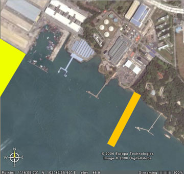
The relocation will involve building a cofferdam about 200-300m
long, 10m deep and 50-70m wide. Excavation for the submarine
cables after the cofferdam is built, in order to minimise impact
on Labrador Nature Park. Work on the cofferdam will start in
Jul 06 and half of Labrador shore will be hoarded up for safety
during the construction. There is a provision in the contract
to introduce silt screens during construction of the cofferdam
if it is found necessary. (see below for what
is a cofferdam)
Prof Chou had done a complete review of biodiversity on Labrador
shore covering species richness (qualitative), species abundance
(quantitative) and species distribution (mapping). He noted
that Labrador Park is currently impacted by visitor load (e.g.,
school children), undetected collection and unregulated fishing
from the jetty.
In his biodiversity study, he found that there is a belt of
corals between 5m and 8m, rather than the normal coral reef
profile. The study also showed that both coral cover and genera
on the eastern end of the belt were higher than the proposed
location of the cofferdam and to the west of it. He cited the
lack of hard substrate on the western end one of the possible
reasons for this.
The plan is to relocate corals in the path of the cofferdam.
About 30% of corals will be relocated, focusing on some species
and not all, e.g. species only found in the affected path, and
others such as Acropora. It was decided that it would
be less stressful on the relocated corals to relocate them to
Labrador itself and not another reef. They will be relocated
east and west of the existing reef and relocated back after
the cofferdam is constructed in about one-and-a-half years'
time. There is a lack of hard substrate on the western side
and precast concrete structures will be placed there for the
relocated corals. The relocated corals will be monitored every
quarter. Relocation will be done at high tide. Prof Chou proposed
restricting visitor access to the services route for a few years
to facilitate natural regeneration.
Prof Chou mentioned that they are expecting natural recruitment
to occur. Prof Chou was asked when the relocation is expected
to start and he answered that it would start this weekend (12
May starting) and it will be carried out by his team. Labrador
is expected to remain open to the public except for the cofferdam
are which will be blocked off "for safety reasons".
There was a brief Q&A, info provided incorporated into the
summary above.
In addition, NSS and SUF offered to help Prof Chou in relocation.
SUF asked DHI to provide spill data to SUF for safety of its
members' activities.
NSS also presented the book "Singapore Waters" to
MPA at the end of the meeting. And wildsingapore distributed
a powerpoint of photos of corals and other marine life commonly
encountered on the intertidal to all government and NGO representatives
present at the briefing.
Any queries and request for viewing of EIA can be sent via email
to EIAqueries@mpa.gov.sg
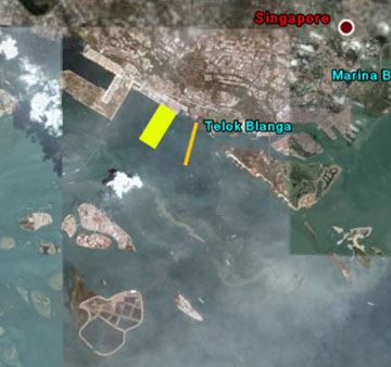 New
terminal (yellow rectangle)
New
terminal (yellow rectangle)
Relocated submarine cables (orange line)
 |
What is a cofferdam?
from Wikipedia's
article on dams
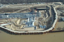 A
cofferdam is a (usually temporary) barrier constructed to exclude
water from an area that is normally submerged. Made commonly
of wood, concrete or steel sheet piling, cofferdams are used
to allow construction on the foundation of permanent dams, bridges,
and similar structures. When the project is completed, the cofferdam
may be demolished or removed. See also causeway and retaining
wall. A
cofferdam is a (usually temporary) barrier constructed to exclude
water from an area that is normally submerged. Made commonly
of wood, concrete or steel sheet piling, cofferdams are used
to allow construction on the foundation of permanent dams, bridges,
and similar structures. When the project is completed, the cofferdam
may be demolished or removed. See also causeway and retaining
wall.
from Cofferdam
Construction By Alex Kruggel March 31, 1999
Advantages of a cofferdam
Allow excavation and construction of structures in otherwise
poor environment
Provides safe environment to work
Contractors typically have design responsibility
Steel sheet piles are easily installed and removed
Materials can typically be reused on other projects
Disadvantages of a cofferdam
Special equipment required
Relatively expensive
Typically very time consuming & tedious
If rushed, sheets can be driven out of locks or out of plumb
When in flowing water log jams may occur creating added
stress on structure
Cofferdam construction on shores
Cofferdams are used to build lighthouses
from Lighthouse
evolution and typology
by Dr Rober Browning on the US Coast Guard website
Cofferdam construction was used where it was desired to build
the foundation on a dry site and where it was not necessary
to penetrate the sea-bed to any great depth. This method could
only be used in very shallow water. The wooden walls of the
cofferdam were constructed ashore, taken to the site, assembled
into a box in the water, bolted together and sealed, and the
water pumped. Workmen then entered this open-topped structure
and prepared the foundation for the lighthouse. The light pictured
here is the Robbins Reef Light.
Cofferdams are also used to salvage shipwrecks
see Shipwreck
Central
Back to
Labrador Nature Reserve factsheet |
|