 EXPLORE•EXPRESS•ACT! |
Geography
of Ubin Pulau Ubin is the second largest of Singapore's offshore islands. (The largest is Pulau Tekong, just next to Pulau Ubin). Lying in the Straits of Johor opposite Changi, Pulau Ubin has been described as being boomerang shaped. About 1,020 ha or 10.2 sq km in area, it is about 8km at the longest length, and its breadth varies from 1.3-1.7km. The highest point of Ubin is Puaka Hill (74m). There are two major offshore islets near Ubin: Pulau Sekudu or Frog Island (opposite Chek Jawa), and Pulau Ketam (opposite Ubin Lagoon Resort) Pulau Ubin has several rivers meandering through it; the main ones being Sungei Besar and Sungei Mamam. Pulau Ubin is made up mostly of granite. This fact has shaped much of the island's activities. Even its name arises from it. One account says that this kind of granite was used to make floor tiles, called "jubin" in Malay. Another says "Ubin" was the Javanese term for square stone. About granite quarrying |
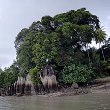 Distinctive rocks of Pulau Ubin..  Disused quarries are beautiful, but don't get too close! |
Links
|